
10 Great Hikes in the Grand Valley: Palisade, Grand Junction & Fruita
Share
The Grand Valley of western Colorado is a landscape of contrasts: soaring sandstone cliffs rise from desert sagebrush, cottonwood-lined rivers meander through town, and high-country streams tumble down from the slopes of the Grand Mesa. For hikers, this region is a dream — every direction offers a new terrain, a new view, and a new challenge. From mellow riverside strolls to demanding climbs, here are nine hikes that showcase the best of Grand Junction, Fruita, and Palisade - and one that takes you further upward into the Grand Mesa.
The Ribbon
For sheer drama, few hikes in the Grand Valley rival The Ribbon. Beginning high on Little Park Road, this 6.5-mile point-to-point trail flows across massive slabs of sandstone that tilt toward the valley floor like nature’s own superhighway. The terrain is exposed, rocky, and at times dizzying, but the views are unforgettable: the Colorado National Monument sprawls to the west, the Book Cliffs stretch to the north, and the Grand Mesa looms to the east. Because it drops more than 1,500 feet, some hikers arrange a shuttle to take them back up to the trailhead, though hardy adventurers can climb it in reverse. Plan three to four hours, and bring plenty of water — the slickrock reflects the sun.
- Local tip: This is a great place to take visitors who aren’t looking for a long hike. Simply take the short walk out to the slickrock portion and explore a bit, be dazzled by the views, and find your way back to the car when you’re satisfied!
- Best season to hike The Ribbon: Best in spring and fall; avoid summer heat due to full sun exposure. It’s quite beautiful in the winter too, but be extra careful and wear good hiking boots to avoid slipping.
Rough Canyon Loop Trail
About 15 minutes from downtown Grand Junction, the Rough Canyon Loop offers a rugged taste of canyon country. This 6.4-mile route begins at the Bangs Canyon trailhead off Little Park Road (same parking lot as Mica Mine trailhead) and weaves through a canyon with sandstone outcroppings, desert scrub, and seasonal creeks. In spring, small waterfalls sometimes cascade through the canyon, while in fall the cottonwoods turn golden against the red rock walls. Rated moderate to strenuous, the loop features slickrock scrambles and uneven footing, but rewards hikers with quiet solitude and sweeping vistas. Take your time getting around the big swimming hole-style potholes in the canyon; it can be slightly perilous. Allow three to four hours for the full circuit.
- Local tip: Doing the trail in reverse (taking the more exposed Tabeguache Trail section first) makes for an easier, often shadier route back up to the parking lot. This is especially helpful in the mid-summer heat!
- Best season to hike Rough Canyon Loop: Spring and fall are ideal, especially when seasonal waterfalls flow. For summer hikes, do a late afternoon out-and-back hike from the Rough Canyon entrance (vs. the slickrock Tabeguache Trail side) and turn around when the canyon opens up to those big views.
Palisade Rim Trail
Overlooking vineyards, orchards, and the lazy bends of the Colorado River, the Palisade Rim Trail combines agricultural charm with dramatic canyon scenery. This 8.8-mile out-and-back climb (with a loop in the middle) begins just outside Palisade, about 25 minutes from downtown Grand Junction. The rocky trail zigzags upward past petroglyphs to higher cliffs where panoramic views of the Grand Valley await. The terrain is dry and exposed, so this hike is best in the cooler seasons. Rated moderate to strenuous, it usually takes four to five hours round trip, but every step up the rim opens new perspectives over the valley’s patchwork of farms and red rock canyons.
- Local tip: Watch for mountain bikes!
- Best season to hike Palisade Rim Trail: Fall and spring are best; summer is very hot, and winter can be icy.
Mount Garfield Trail
A rite of passage for locals, the Mount Garfield Trail is short, steep, and spectacular. Climbing 2,000 feet in under two miles, the 3.5-mile round trip is strenuous from the start, with loose scree and sandstone ledges testing even fit hikers. But the summit delivers — from the top of the Bookcliffs, the Grand Valley spreads out in full view, framed by the Colorado River and Grand Mesa beyond. Located just 15 minutes from downtown, this hike typically takes three to four hours. Go early in the day to beat the sun and wind, and do your best to beat the sunset at the end of the day. This isn’t a hike you want to finish in the dark.
- Local tip: Wear your best hiking shoes for this trail, and if you have hiking poles, bring them. The loose, rocky soil at the steep beginning of this hike is just as difficult, if not moreso, on the way down.
- Local tip #2: If there has been significant precipitation in the days leading up to your Mount Garfield hike, give it a bit to dry out, or check trail conditions before you go. Not only does hiking in saturated soil mess up the trail, but the wet clay will stick to your shoes in inches, and will likely make ascent (and descent) more problematic than it’s worth.
- Best season to hike Mount Garfield: Year-round, but best in spring and fall. In winter, expect icy conditions on the steep ascent.
Pollock Bench Trail
For those seeking wide-open desert beauty with fewer crowds, the Pollock Bench Trail near Fruita delivers. This 7-mile loop winds through sagebrush flats and slickrock benches, with scenic hints at the wonders of nearby Rattlesnake Canyon. The trail is rated moderate, with rolling elevation changes and a mix of sandy paths and rocky ledges. Plan three to four hours. Just 30 minutes from downtown Grand Junction, it’s an ideal escape for anyone craving big skies and quiet canyon views.
- Local tip: This trail is the warm-up for the long route to Rattlesnake Arches; see below.
- Best season to hike Pollock Bench: Spring and fall are the most comfortable; avoid peak summer afternoons.
Rattlesnake Arches Trail
Often called the second-largest concentration of natural arches in the world (after Arches National Park), Rattlesnake Arches is one of the Grand Valley’s crown jewels. Take your pick of two ways to get there: a rugged 15-mile 4x4 road leading to a short, less-than-2-mile hike, or a more popular 15.5-mile round-trip hike from the Pollock Bench trailhead. Either way, the reward is jaw-dropping — a cluster of sandstone arches, windows, and spans that seem almost impossible in scale. The terrain is challenging, with slickrock, sandy washes, and steep climbs, so expect a strenuous outing that can take all day. From Grand Junction, the Pollock Bench trailhead is about a 25-minute drive.
- Local tip: The longer hike via the Pollock Bench trailhead makes a great backpacking trip in the cooler spring and fall months. As for water, the route does have an option to descend to the Colorado River, but don’t underestimate the descent; it’s off the beaten path and somewhat gnarly.
- Best season to hike Rattlesnake Arches: Spring and fall for cooler weather; summer is brutal, winter can be snowy.
Devil's Canyon Trail
Easily accessible yet endlessly rewarding, Devil’s Canyon is a gem in the McInnis Canyons National Conservation Area outside Fruita. The main loop is about 5 miles, but several side trails invite exploration. The route meanders through towering red rock walls, past hidden alcoves, and across sandy washes dotted with junipers. Rated easy to moderate, it’s a decently family-friendly hike that still offers grandeur on par with national parks. From downtown Grand Junction, it’s a 25-minute drive, and most hikers spend two to three hours wandering its labyrinth of canyons. Park at the Devil’s Canyon Trail System parking lot off Kingsview Road/ Horsethief Canyon Road.
- Local tip: The Devil’s Canyon trail system connects to the Flume Canyon trail, which also connects with Pollock Bench and Rattlesnake Arches. You could easily do a full day of desert exploration in this area! Just bring more water and a good hat.
- Best season to hike Devil’s Canyon: Excellent year-round, but cooler temperatures in winter make it especially enjoyable.
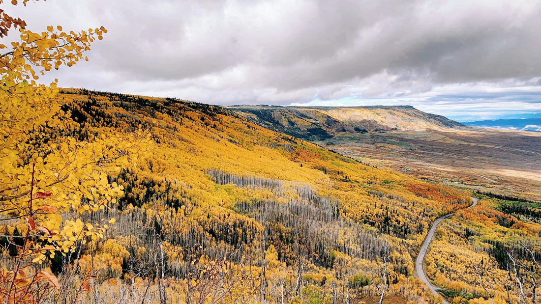
Kannah Creek Trail
On the slopes of the Grand Mesa, the Kannah Creek Trail offers a cool, forested contrast to the desert hikes below. This trail is about 9 miles one way, and if you start at the bottom, you’re looking at nearly 4,000 feet of elevation gain! Going up, the trail follows the creek upstream, weaving through spruce and aspen groves, with waterfalls and wildflowers in spring and fiery foliage in fall. The terrain is moderate, with steady climbs but no technical sections, making it a favorite for those wanting a longer day hike in a mountain setting. It’s about a 40-minute drive from downtown Grand Junction to start at the bottom, or 90 minutes to start at the top. Most hikers spend four to five hours on the trail (going downhill).
- Local tip: The Kannah Creek trail is wonderful with a shuttle plan in place! Park one car at the top or bottom - wherever the end of the trail is for you - and shuttle back to where you began when it’s over. You’ll thank yourself later.
- Best season to hike Kannah Creek Trail: Best in summer and fall when the high country is open; snow lingers into late spring.
Riverfront Trail
Not every hike needs to be a rugged climb. The Riverfront Trail offers a gentle, paved path that stretches more than 20 miles along the Colorado River, linking Palisade, Grand Junction, and Fruita. Popular sections include the Audubon Section near the Botanical Gardens and the stretch through Connected Lakes State Park. The terrain is flat and easy, perfect for families, strollers, or anyone seeking a peaceful riverside walk. Time is flexible — you can walk for 30 minutes or several hours — and access points are just minutes from downtown.
- Local tip: Be careful when the river is high during spring runoff season! Some parts of the trail may be closed due to high water.
- Best season to hike Riverfront Trail: Year-round, but some parts of the trail are exposed, so avoid sunny summer afternoons in those areas.
Serpents Trail (Colorado National Monument)
History and scenery combine on Serpents Trail, a 3.5-mile out-and-back in Colorado National Monument. Once dubbed “the Crookedest Road in the World,” this former automobile route is now a hiker’s path, switchbacking up the canyon wall. The climb is steady but never extreme, making it a moderate hike that usually takes one to two hours. Along the way, you’ll gain sweeping views of Grand Junction and the surrounding mesas. The trailhead is just inside the east entrance of the monument, about 15 minutes from downtown. Keep in mind that you'll need a day pass or Parks pass to get into the Monument, and dogs are not allowed on any trails in the park!
- Local tip: To give visitors a sweeping view without too much uphill work, park at the small parking lot at the top of the trail and wander down a few curves. You’ll be able to peek off the sides for some of the best vistas before hiking a short distance back up.
- Best season to hike Serpents Trail: Spring and fall are perfect. It’s quite hot in the summer, so aim for morning hikes.
Need hiking gear?
Stop by The Gear Junction before your next adventurous hike to shop our new and used outdoor gear! Looking for something specific? Call us and we'll tell you if we have it.
